
Detecting drought impact on grassland via GOSAT “Ibuki” satellite-observed chlorophyll fluorescence
1. Research Background and Objectives
GOSAT projects are promoted by the Ministry of the Environment of Japan, the National Institute for Environmental Studies (NIES), and the Japan Aerospace Exploration Agency. GOSAT Earth observation satellites have the primary objective of measuring greenhouse gases. The first satellite, “Ibuki”, has been in operation since its launch in January 2009; its successor, GOSAT-2 “Ibuki-2”, was launched in October 2018. From GOSAT and GOSAT-2 data, the intensity of solar-induced chlorophyll fluorescence (SIF)1 emitted from terrestrial vegetation can be calculated, as can greenhouse gas concentrations. SIF is weak radiation emitted from leaves during photosynthesis. SIF observed by GOSAT satellites is used in terrestrial ecosystem research as an indicator of plant photosynthetic activity. During photosynthesis, leaves not only take in carbon dioxide, but also influence precipitation through transpiration, thus regulating climate. Photosynthesis is essential to food production, but it is susceptible to adverse effects of climate change such as drought and temperature extremes, so it is crucial to monitor plant photosynthetic activity. Over the past decade, the Mongolian Plateau has experienced frequent droughts, raising concerns about their effects on ecosystems and human society.
The objectives of this study were to investigate whether GOSAT SIF observations could detect the impact of drought on a grassland in the Mongolian Plateau, and to identify which drought-induced environmental factors that cause plant responses were reflected in changes in SIF values.
2. Research Method
We conducted a time series analysis of a grassland on the Mongolian Plateau, which spans Mongolia, China and Russia, using SIF data from GOSAT observations from 2009 to 2018, temperature, precipitation and soil moisture content, and leaf area index2 based on Aqua MODIS data. We also estimated the photosynthetic activity of the grassland.
3. Research Results and Discussion
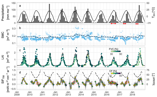
Precipitation varied widely, and was very low in the early summers of 2016, 2017 and 2018 (Fig. 1a). Large annual variations occurred also in soil moisture content (SMC; Fig. 1b), leaf area index (LAI; Fig. 1c) and SIF (Fig. 1d). Most changes in LAI and SIF were linked; however, in August 2010, June 2013, July 2016 and July 2017, when SMC was ≤15% (Fig. 1d), LAI did not decrease despite lower SIF. That is, overall, leaf cover determined the intensity of SIF, but as the soil dried, SIF values continued to decrease even when leaf area did not.
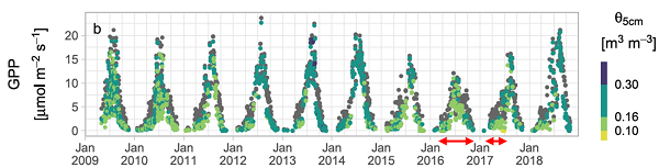
Gross primary production also decreased in 2016 and 2017, when SIF was markedly low (Fig. 2, red double arrows), indicating that soil drought reduced it.
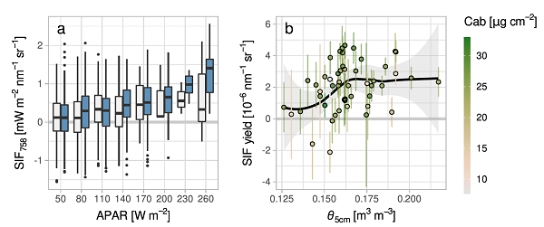
SIF increased as light absorption by leaves increased, but under dry conditions (SMC < 15.4%), it plateaued while light absorption continued to increase (Fig. 3a). We calculated the SIF yield as SIF divided by light absorption, and plotted SIF yield against SMC at 5 cm (Θ5 cm): it was low at around 15% SMC and increased markedly at higher soil moisture contents (Fig. 3b). In some cases, even when SIF yield was low under dry conditions, the chlorophyll content was high, meaning that the leaves did not wilt and remained green (green symbols in Fig. 3b).
Our findings show that on the Mongolian Plateau, SIF values decrease in response to soil drought, which adversely affects plant photosynthetic activity, even when the leaves do not wilt. Several methods have been proposed for monitoring vegetation status from satellite data, but they are useful only in identifying wilting leaves. As we have shown here, SIF is an excellent indicator of impacts from soil drought on herbaceous vegetation before plants wilt.
4. Prospects
We used SIF data collected by GOSAT. GOSAT-2 also measures SIF, and GOSAT-2 SIF data sets have been released to the public. The third GOSAT satellite, the GOSAT for Greenhouse Gases and Water Cycle (GOSAT-GW), is scheduled for launch during Japanese FY 2024. GOSAT-GW will be capable of performing more spatially precise SIF observations than GOSAT and GOSAT-2. As global warming progresses, the frequency and intensity of drought are expected to increase in other regions besides the Mongolian Plateau. We believe that GOSAT SIF data will play an important role in promptly assessing the damage to ecosystems caused by drought.
5. Notes
1) Solar-induced chlorophyll fluorescence (SIF) is chromophyll fluorescence emitted by plants during photosynthesis under sunlight. SIF is measured by using the wavelength band where Fraunhofer lines and chlorophyll fluorescence wavelengths overlap. GOSAT Ibuki is the world’s first satellite that can measure global SIF. 2) Leaf area index (LAI) is the total area of all leaves divided by the ground area beneath them. Higher LAI values indicate more leaves above the ground. 3) Gross primary production (GPP) is the total amount of photosynthetic production during photosynthesis. In this study, GPP values were estimated.
6. About the Article
[Title] Regional-Scale Wilting Point Estimation Using Satellite SIF, Radiative-Transfer Inversion, and Soil-Vegetation-Atmosphere Transfer Simulation: A Grassland Study [Authors] Tomoki Kiyono, Hibiki M. Noda, Tomo’omi Kumagai, Haruki Oshio, Yukio Yoshida, Tsuneo Matsunaga, and Kouki Hikosaka [Journal] Journal of Geophysical Research: Biogeosciences [URL] https://agupubs.onlinelibrary.wiley.com/doi/full/10.1029/2022JG007074 (a link to an external site) [DOI] https://doi.org/10.1029/2022JG007074 (a link to an external site)
7. Authors of This Press Release
Senior Researcher Hibiki Noda
Satellite Remote Sensing Section, Earth System Division
8. Contact Information
[Contact for this research]
Senior Researcher Hibiki Noda
Satellite Remote Sensing Section, Earth System Division, National Institute for Environmental Studies
[Contact for this press release]
Public Relations Office, Planning Division
National Institute for Environmental Studies
E-mail: kouhou0 (please append ‘@nies.go.jp’ to complete the e-mail address)
- What's New
- What's New 2024
- What's New 2023
- What's New 2022
- What's New 2021
- What's New 2020
- What's New 2019
- What's New 2018
- What's New 2017
- What's New 2016
- What's New 2015
- What's New 2014
- What's New 2013
- What's New 2012
- What's New 2011
- What's New 2010
- What's New 2009
- What's New 2008
- What's New 2007
- What's New 2006
- What's New 2005
- What's New 2004
- What's New 2003
- What's New 2002
- Event Information
- Visit NIES